Related Content
Station Papa
MARS
Cabled Observatory-Endurance Line

OOI Regional Cabled N ...
The fiber-optic cables of the Regional Cabled Network, the cabled component of t ...


Earthquakes in the NE ...
Seismicity plays a critical role in shaping the face of our planet, in creation o ...


Observatories
We must understand the oceans to optimize the benefits and mitigate the hazards o ...

NEPTUNE Canada
The early design and development phases of NEPTUNE Canada were nurtured and encou ...

Ocean Observing in the NE Pacific
Global Phenomena

Locations of Ocean Observing Systems in the NE Pacific
NE Pacific Observatory Locations
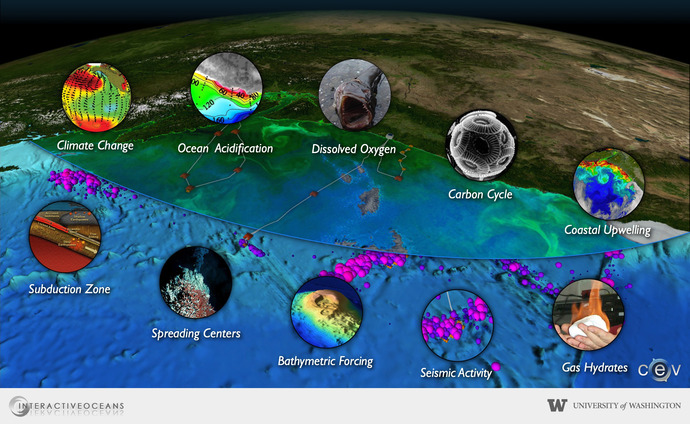
A representative suite of natural phenomena that occur in the Northeast Pacific Ocean are also found throughout the world's oceans and seafloors.
The U.S. Cabled Ocean Observatory
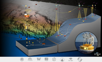
The University of Washington is leading the design, development, and construction of the NSF Ocean Observatories Initiative's Regional Scale Nodes. This novel cabled ocean observatory will be launched as a nearly 900-km cable across the Juan de Fuca tectonic plate, running from a shore station in Pacific City, Oregon, out to the Juan de Fuca Ridge and south along the Cascadia subduction zone to Hydrate Ridge. Nodes densely populated with instruments and full water column moorings will be installed at study sites at Hydrate Ridge, Axial Volcano, and to shallow coastal sites west of Newport Oregon. High bandwidth data and video imagery will be transmitted in real-time via the Internet and will be accessible to users around the world, to scientists, educators, students, and decision-makers. The system will have a 25-year lifetime.
The network is designed to be expandable and the vision remains to create an observatory that, when complemented by NEPTUNE Canada, will encompass an entire tectonic plate and all the natural phenomena that occur there, whether below the seafloor, on the seafloor, in the ocean, or at the air-sea interface.
NEPTUNE Canada
NEPTUNE Canada, led by the University of Victoria, is building the northern loop of the regional ocean observatory network in the northeast Pacific Ocean. This cabled seafloor observatory off the west coast of Vancouver Island, British Columbia also extends across the Juan de Fuca plate and has nearshore nodes. Data will be transmitted to a data archiving system at the University of Victoria. As with the U.S. observatory, NEPTUNE Canada is designed for a 25-year lifetime.
VENUS
The Victoria Network Under the Sea (VENUS) is a shallow-water cabled observatory run by the University of Victoria. Deployed in the coastal waters of southern British Columbia, the facility is providing long-term oceanographic data on physical, chemical, biological, and sediment conditions in Saanich Inlet and in the Strait of Georgia near Vancouver, British Columbia.
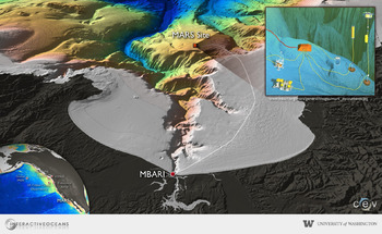
MARS
The Monterey Accelerated Research System is a deep-water testbed for scientists and engineers who want to design and test instruments that will be used on ocean observatories. Located at 891 meters depth near the rim of the undersea canyon in Monterey Bay, California, MARS is operated by the Monterey Bay Aquarium Research Institute. The MARS facilities allow researchers to develop the tools and protocols necessary to take advantage of a seafloor power supply, real-time, high-bandwidth data transfer, and real-time control of experiments. Developments on MARS are readily transferable to other cabled observatories.
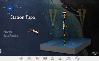
Ocean Station Papa
Ocean Station Papa is a mooring located in the Gulf of Alaska at 50°N and 145°W. Instruments have been collecting ocean and atmospheric data at this location for nearly 60 years. Ships, and surface moorings have each taken their turn "occupying" this site. The Ocean Observatories Initiative will install a rugged mooring, with an array of sensors and capable of real-time communication via satellite. In addition, underwater vehicles such as gliders will extend the horizontal coverage of the site.
The oceans in the high latitudes of the planet are particularly sensitive to global climate change, yet their remote and hostile environments make them difficult to study. Station Papa, combined with the other ocean observing components in the NE Pacific, will contribute to four-dimensional studies in this representative portion of the global ocean.
Endurance Array
The OOI Endurance Array will be a series of permanent moorings off the Central Oregon coast. In addition to the 3000 m mooring east of Hydrate Ridge, two sites with full water-column moorings at 500 and 80 m will be connected to the Regional Scale Nodes cable and will be served with high bandwidth and high power. The Array will also include a network of undersea gliders programmed to patrol the nearshore waters and collect a variety of data and transmit it to onshore laboratories.
At the interface of the deep sea of the Pacific Ocean and the coastline, this dynamic area off the Central Oregon coast includes rich habitats for marine life, hydrothermal vents, deposits of frozen methane, storm-induced waves that cause onshore erosion, and the Cascadia Subduction Zone, which can produce large earthquakes and tsunamis. This area also includes the California Current system and has a significant influence on regional and national climate. Changing ocean conditions in this area created a recent series of hypoxic events and harmful algal blooms.