Enlighten '10
  • Other Sites
    • VISIONS '11
    • ENLIGHTEN '10
    • University of Washington
  • Home
  • Cruise
    • Overview
    • Daily Log
    • OOI
    • Partnerships
    • Participants
    • Mission
  • Operations
    • Overview
    • Sediment Sampling
    • Water Sampling
    • Mapping Washington Margin
    • Mapping Hydrate Ridge
    • Mapping Axial Volcano
  • Education
    • Overview
    • Sea-going Research & Discovery
    • Student Projects
  • Science
    • Overview
    • Endurance Line
    • Axial Volcano
    • Hydrate Ridge
    • Washington Uncabled Line
  • Technology
    • Overview
    • Satellite
    • Reson Sonar
    • Chirp Sonar
    • HD Imagery
    • ROV Jason
    • AUV Sentry
    • Gravity Core
    • CTD
    • COVE
    • EM 300 Sonar
    • RV Thompson
  • Arts
    • Poetry
  • Gallery
    • Shipboard Images
    • Seafloor Images
    • Documents
    • Samples
    • Maps
  • Video

Station Papa

Station Papa

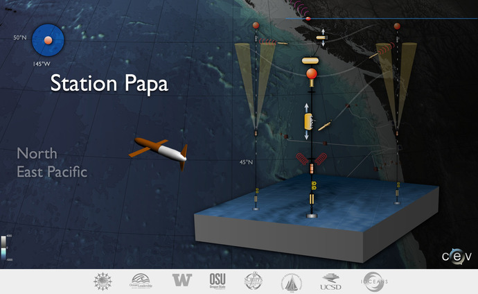
Station Papa in the North East Pacific - High Latitude OOI mooring

Related Stories

Ocean Observing in the NE Pacific
 
Creative Commons License 

For commercial use or higher resolution please contact Nancy Penrose


Enlighten '10
Follow us on Facebook
Follow us on Twitter
YouTube
Flickr

University of Washington. All rights reserved. Website Development and Design: Center for Environmental Visualization