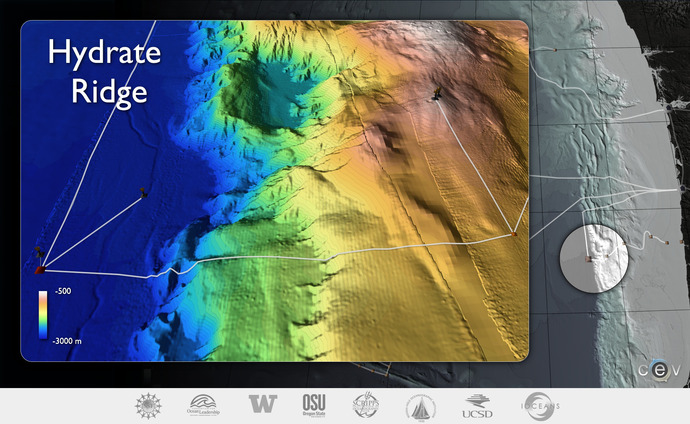
Hydrate Ridge
Although the global distribution and actual quantities of gas hydrate are not known, it has been estimated that the carbon bound in gas hydrates is ~2 times that of carbon in all known fossil fuels.

Methane from hydrate deposits represents a significant reservoir of carbon.
Energy.

The planned secondary infrastructure at the base of Southern Hydrate Ridge.
Hydrate Ridge
Understanding Gas Hydrate Deposits
A significant amount of methane near the surface of the Earth is locked in gas hydrates buried in the shallow sediments of continental margins. The hydrates may act as a capacitor in the carbon cycle by slowly storing methane that can be suddenly released into the ocean and atmosphere during seismic events or slope failure. Hydrate Ridge in the Cascadia accretionary complex, is one of the best-studied gas hydrate deposits. Significant methane seeps hosting diverse biological assemblages and formation of gas-rich hydrate deposits near the seafloor have been documented here. Studies of these deposits have provided a good understanding of how gas hydrate is distributed in marine sediments and of the processes that lead to heterogeneity in distribution.
A Cabled Observatory at Hydrate Ridge
Hydrate Ridge is an optimal place for ocean observatories to examine the temporal evolution of these dynamic systems, to determine the fluxes of methane from the seafloor into the ocean, and to understand the biogeochemical coupling associated with gas-hydrate formation and destruction. One of the Regional Scale Nodes study sites will be located at Hydrate Ridge. The real-time interactive capabilities of the cabled observatory are critical to studying gas-hydrate systems because many of the key processes may occur over short time scales and will require adaptive response and sampling capabilities that include fluid sampling, increases in data accumulation rates and imagery from cameras, and in situ manipulation of chemical sensors.
The high power and bandwidth capability of the Regional Scale Nodes component of the OOI is required to enable man-made perturbations to the system (e.g., fluid pumping; heating of the system to avoid hydrate formation during fluid sampling or to perturb the hydrates), operations that include downhole seismic and/or electromagnetic sources, multiyear deployments that are needed to capture the various time scales operating in this system, and the need for real-time intervention to capture infrequent events or otherwise change experiment parameters that could not be made by passive monitoring. Significant expansion capabilities at this experimental site will provide access to a wealth of follow-on experiments that may include downhole observatories and incorporation of autonomous vehicles for repeat, high-resolution mapping and imaging of the methane seeps and deposits, associated biota, and plumes.