Enlighten '10 Operations Index

Operations
Operations on the Enlighten'10 expedition are focused on obtaining meter-scale ba ...
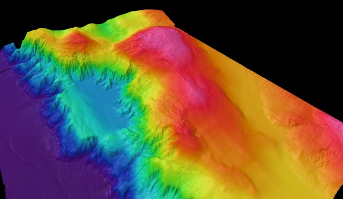
Mapping Hydrate Ridge
A Natural Laboratory for Studying Linkages Among Gas Hydrate Formation and Life
Southern Hydrate Ridge is a focused research area as part of the high power and bandwidth Regional Scale Nodes cabled observatory. This area is one of the most well studied gas hydrate systems in the world's oceans because it hosts abundant methane hydrate deposits, sites of active venting of fluids and methane-rich gases, and dense microbial and animal communities fueled by the seeps. An array of chemical, biological, and geophysical sensors at this site, which will be installed in 2013, will allow the first long-term, detailed investigation of, for example, the impacts of seismic events on release of hydrates and methane gas into the overlying ocean, and changes in microbial and animal communities over time. In situ cameras, flow sensors, and a mass spectrometer will allow investigation of how changes in fluid flow and chemistry impact the biological communities that thrive in this environment. Methane gas is a powerful green house gas and, therefore, quantifying the flux of methane from the seafloor into the hydrosphere is critical to understanding carbon cycle dynamics and the impacts of global warming on methane release.
A major goal of the Enlighten expedition will be to use the AUV Sentry and the ROV Jason to produce a < 1 m resolution bathymetric map of the seep sites at Southern Hydrate Ridge, and a complete mosaic of the instrumentation sites. It is hoped that comparison of the map completed during this cruise, and one completed during the INSITE'08 cruise will provide the first documentation of how hydrate deposits and venting sites have changed during the past two years. Direct seafloor imaging with a high definition camera on Jason will be used to examine animal and microbial communities and venting from the seeps. We will also photomoasic a 50 m-tall carbonate pinnacle at this site.