Sensors and Moorings: Overview
The instrument packages and sensors on the RSN provide the means to monitor and sample the water column (therefore sharing many functions with the Coastal/Global Scale Nodes mooring sensors) and they also include an extensive suite of geophysical and chemical sensors to examine plate tectonic, volcanic, chemical, hydrothermal, and biological processes. The architecture includes a set of core sensors, however, it also includes the capacity to increase the number and type of instruments over the life of the OOI to expand the coverage area and address new scientific questions.
The RSN infrastructure enables instruments to have cabled connections for power and 2-way communications (commands and data) to all elements 24/7/365. As described in other sections, the RSN sensors obtain power and communications from the Low Voltage Nodes, and Medium Power and Low Power J-Boxes via extension cables.
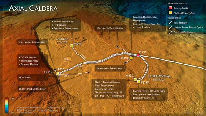
A wide variety of sensors are needed to provide required measurements. Commonly, these instruments need to be co-located and the data accurately timed. Sensors are grouped in instrument packages that are presented by functional measurements. To meet the Science Requirements there are 16 different types of core seafloor sensors and 17 core water column sensors, with a total of 108 sensors on the RSN system. As described in the RSN L4 Instrument Package Requirements Document, instrument packages include a Basic Core Seafloor Measurements Package (BCSM); Vertical Mooring Measurements Package (VMM), and a set of Site-Specific Measurements Package (SSM) with co-registered environmental and visual measurements at key plate locations that include the following:
- Zones of active magmatic activity
- Zones of hydrothermal flow
- Zones of subduction and sedimentary wedge formation
- Water Column Measurements
- Benthic Boundary Layer Measurements
- Horizontal Context Measurements
- Zones of gas hydrate formation and methane seeps