
Secondary Infrastruct ...
The RSN’s Secondary Infrastructure is shown schematically in the figure abo ...
Moorings
Water-Column Moorings on the RSN

Block Diagram for all components of the Water Column Moorings. One mooring will be at Node 1A near the base of the accretionary margin near Hydrate Ridge and another at the base of the eastern flank of Axial Seamount on Primary Node 3A.
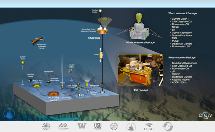
Vertical Mooring Block Diagram

Moorings Image
Moorings Image
Ocean conditions surrounding the RSN are bracketed on the pelagic or open-ocean end by the OOI global site at Ocean Station Papa, and on the coastal end by the Endurance Array. The RSN resides in a complex system of currents, where wind- and tide-forced motions lead to turbulent mixing that aids transport of chemical and biological species. The Pacific Northwest is one of the most biologically productive regions of the world, hypoxia, ocean acidification, and harmful algal blooms are observed with increasing frequency. These complex physical, biological and chemical processes are all intertwined, and respond to forcing on a wide range of spatial and temporal scales. The water column moorings at Hydrate Ridge and Axial (see figure above) are well suited to resolve these processes, and the system’s response to changing forcing conditions resulting from climate change. The unprecedented power (375V) and bandwidth (Gb/s) capabilities of these moorings allow for a broad suite of sensors that include real-time digital imaging and acquisition of high bandwidth sonar and hydrophone data for biological applications.
The Vertical Mooring Measurement Package (VMM) is located at two sites, one ~4.5 km east of Node 1A (Hydrate), and one ~4.5 km northwest of Node 3A (Axial). The VMM consists of a Basic Core Seafloor Mooring Measurements package (BCSMM) located meters from the base of the vertical mooring assembly, a Profiler Instrument Package that is located on a profiler that traverses from just off the seafloor to the base of a platform located at 200 m beneath the sea surface, a Float Instrument Package located on the 200 m subsurface platform, and a Winch Instrument Platform located on a winch that travels from the 200 m platform to just beneath the surface.
Mooring at Hydrate Ridge
Though both moorings are in about 3000 m of water, they have very different oceanographic foci. The mooring at Hydrate Ridge is situated adjacent to the coastal continental slope at the end of the Endurance Oregon Line, and in concert with the northern Endurance Washington Line, provides a unique opportunity for investigating a variety of interdisciplinary coastal studies. The coastal region of the Pacific Northwest is a classic wind-driven upwelling system. However, the presence of the Columbia River plume and the range of trajectories with which it can impinge on the ocean, and the strong variability of the width of the continental shelf, all play strong roles in setting the system’s response and behavior. In addition, the aforementioned large-scale systems affect the coastal region by modulating the pycnocline, nutricline and oxycline depths and offshore pressure gradients, which in turn affect the onshore transport of physical, biological and chemical quantities. The presence of internal waves driven by waves and tides, their interaction with the larger-scale currents, and their eventual breakdown into turbulence, are also vital to setting properties in the coastal region. All of these are expected to change strongly over time, but will be well resolved by the measurements at Hydrate Ridge, the Endurance Array, and supporting shipboard work.
Mooring at Axial Seamount
IInfrastructure at Axial Seamount includes a Primary Node 3A located in a benign area roughly 20 km down slope in Thompson Basin at the base of the eastern flanks and a Low Voltage Node (LVO3A). The LV Node supports the Basic Core Seafloor Mooring Measurement Package and a full water-column mooring with its full contingent of sensors, and a profiler and winch. Primary Node 3A also supports a Medium Power J-Box that provides communication to the common suite of Basic Core Seafloor Measurement packages. Meter-scale resolution bathymetry, direct seafloor imaging and a 3.5 kHz sonar survey of this area show that this area is flat and heavily sedimented.
In contrast to the margin setting of Hydrate Ridge, Axial Seamount is far from the continental shelf and hence represents an open-ocean or pelagic site in the continuum of observing scales represented in the OOI’s cabled system. Here, large-scale currents including the North Pacific Current, the subpolar gyre and the northern end of the California Current interact. These currents transport heat, salt, oxygen, and biota, all of which are crucial to the region’s ecosystem. However, their variability arises from forcing as varied as tides and wind (0.5--5 day timescales) to interannual (El Niño) to decadal (Pacific Decadal Oscillation) timescales. Examples of relevant science questions represented in the OOI Science Requirements include 1) Internal tides are ubiquitous vertical motions formed by tidal currents flowing past bottom features such as Axial Seamount. How, and how strongly, do they break down into turbulence, and what are the feedbacks on the large scale current system? 2) What is the impact of long- and short-term forcing changes on the structure and transports of the large-scale current system – and what are their effects on the ecosystem? Together with the mooring at Ocean Station Papa, these processes can be studied with observing platforms in the water column at these two sites.