Endurance Line PN-1C and 1D
Overview
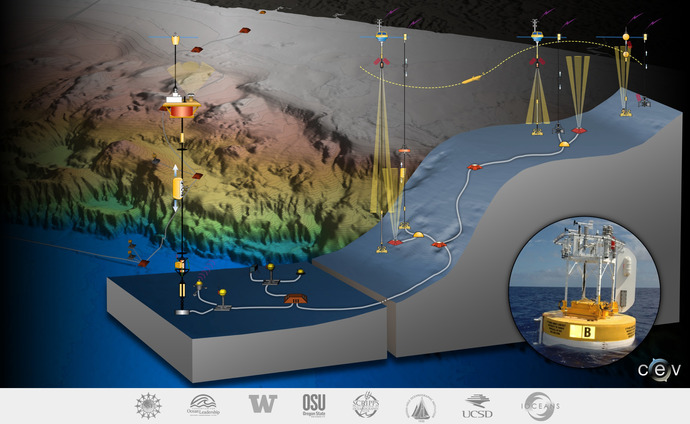
The Endurance Array is a multi-scale array utilizing fixed and mobile assets to observe crossshelf and along-shelf variability in the coastal upwelling region of the Oregon and Washington coasts, while at the same time providing an extended spatial footprint that encompasses a prototypical eastern boundary current regime and overlaps the RSN cabled infrastructure. This integrated infrastructure bridges processes from the coastal zone (Coastal/Global Scale Nodes), through their transition into the ocean basin interior (RSN), and outward to the pelagic North Pacific (Station Papa). In order to provide synoptic, multi-scale observations of the eastern boundary current regime, two cross-shelf moored array lines, each with three instrumented sites, are supplemented by six gliders patrolling the coastal region. The Endurance Array is composed of two lines of moorings, the Oregon Line (also called the Newport Line) and the Washington Line (also known as the Grays Harbor Line).
Endurance Array Oregon Line Technical Approach
The backbone of the Endurance Oregon will be three fixed sites aligned perpendicular to
isobaths and spanning from offshore (500 m), mid-shelf (80 m) and inshore (25 m) regimes
offshore of Oregon. The offshore and shelf sites combine fully-instrumented
surface platforms with cabled profilers and benthic boundary layer sensors. The inshore site
combines a wave-hardened surface platform electromechanically linked to benthic boundary
layer sensors and a stand-alone surface-piercing profiler. The three environments are linked
physically, biologically, and geologically, yet represent distinctly different processes. As an
example, wave forcing is especially important at the 25 m site, while local and remote wind
forcing is dominant at the mid-shelf site and slope currents and offshore mesoscale variability
is important at the slope site.
The most transformative design element of the offshore and shelf sites will be the cabled
infrastructure which integrates the Endurance Array with the Regional Scale Nodes through an
extension from RSN-1 through Nodes 1C and 1D to the Endurance Array
infrastructure. This CGSN-RSN partnership extends the reach and capability of
the RSN infrastructure into the coastal environment, while simultaneously providing the
transformative high-power, high-bandwidth capabilities to the Coastal infrastructure.
Cabled infrastructure of the Endurance Oregon Line is provided through interface requirements
with the RSN and will use the same physical interfaces, command control, and data transport
mechanisms as other RSN components to minimize duplicated design work by RSN, CI or
CGSN. The cabled infrastructure will support an extensive suite of core sensors deployed on
surface-piercing profilers and at benthic boundary layer nodes. Equally important, the cabled
infrastructure will also provide outstanding access for the science user community, enabling
experiments requiring high-power, high-bandwidth sensors. Surface moorings will also be
present at the 500 m and 80 m sites. These moorings will provide continuous meteorological
and near-surface oceanographic measurements.
Further details about the Endurance Array may be found in the OOI Final Network Design document.