
Axial 3000m PN-3A
Axial Seamount is the most robust volcanic system on the Juan de Fuca Ridge and it is both seismically and hydrothermally active (see figure above). It is the only place in the world’s oceans where long-term measurements have been made on the subsurface biosphere, examining changes in microbial communities linked to changes in fluid chemistry following an eruptive event. This site also has a long history of monitoring through NOAA’s NEMO Observatory program that had a moored instrument array here with real-time monitoring capabilities. Instrumentation at this site will provide critical measurements/quantification of carbon dioxide emissions and other volcanic gases into the hydrosphere. Only discrete measurements at any submarine volcano have been made to date, preventing accurate flux measurements to be made. Infrastructure at the summit of Axial Seamount and on the full water-column mooring (see below) support requirements described in OOI Science Requirements documents: A-1 Global Biogeochemistry and Carbon Cycling; A4 Fluid-Rock Interaction and the Subseafloor Biosphere; A-3 Ocean Circulation, Mixing, and Ecosystems; A5-Plate Scale Seismological and Geodynamics; A-4 Fluid Rock Interaction and the Subseafloor Biosphere; A-5 Plate-Scale Seismology and Geodynamics; A-7 Climate Variability and Ecosystems; and A-8 Ocean Mixing and Rough Topography.
Mooring
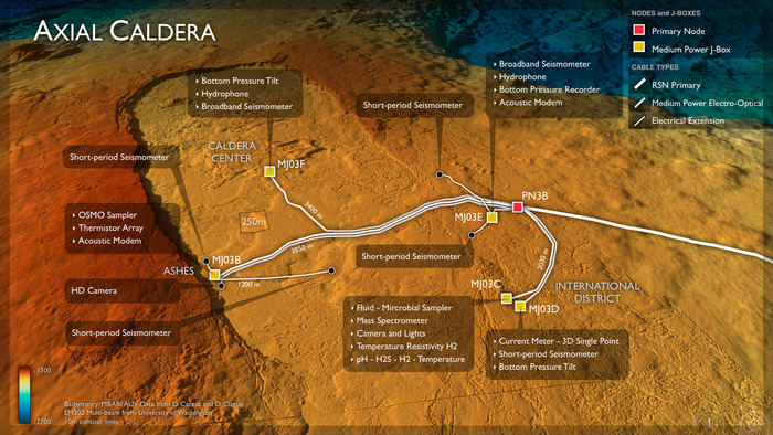
IInfrastructure at Axial Seamount includes a Primary Node 3A located in a benign area roughly 20 km down slope in Thompson Basin at the base of the eastern flanks and a Low Voltage Node (LVO3A). The LV Node supports the Basic Core Seafloor Mooring Measurement Package and a full water-column mooring with its full contingent of sensors, and a profiler and winch. Primary Node 3A also supports a Medium Power J-Box (MJO3A) that provides communication to the common suite of Basic Core Seafloor Measurement packages. Meter-scale resolution bathymetry, direct seafloor imaging and a 3.5 kHz sonar survey of this area show that this area is flat and heavily sedimented.
Axial Seamount is far from the continental shelf and hence represents an open-ocean or pelagic site in the continuum of observing scales represented in the OOI’s cabled system. Here, large-scale currents including the North Pacific Current, the subpolar gyre and the northern end of the California Current interact. These currents transport heat, salt, oxygen, and biota, all of which are crucial to the region’s ecosystem. However, their variability arises from forcing as varied as tides and wind (0.5--5 day timescales) to interannual (El Niño) to decadal (Pacific Decadal Oscillation) timescales. Examples of relevant science questions represented in the OOI Science Requirements include 1) Internal tides are ubiquitous vertical motions formed by tidal currents flowing past bottom features such as Axial Seamount. How, and how strongly, do they break down into turbulence, and what are the feedbacks on the large scale current system? 2) What is the impact of long- and short-term forcing changes on the structure and transports of the large-scale current system – and what are their effects on the ecosystem? Together with the mooring at Ocean Station Papa, these processes can be studied with observing platforms in the water column at these two sites.