Enlighten '10
  • Other Sites
    • VISIONS '11
    • ENLIGHTEN '10
    • University of Washington
  • Home
  • Cruise
    • Overview
    • Daily Log
    • OOI
    • Partnerships
    • Participants
    • Mission
  • Operations
    • Overview
    • Water Sampling
    • Sediment Sampling
    • Mapping Washington Margin
    • Mapping Hydrate Ridge
    • Mapping Axial Volcano
  • Education
    • Overview
    • Sea-going Research & Discovery
    • Student Projects
  • Science
    • Overview
    • Endurance Line
    • Axial Volcano
    • Hydrate Ridge
    • Washington Uncabled Line
  • Technology
    • Overview
    • Satellite
    • Reson Sonar
    • Chirp Sonar
    • HD Imagery
    • ROV Jason
    • AUV Sentry
    • CTD
    • Gravity Core
    • COVE
    • EM 300 Sonar
    • RV Thompson
  • Arts
    • Poetry
  • Gallery
    • Shipboard Images
    • Seafloor Images
    • Documents
    • Samples
    • Maps
  • Video

Volcanoes and Life: Axial Seamount

Volcanoes and Life: Axial Seamount

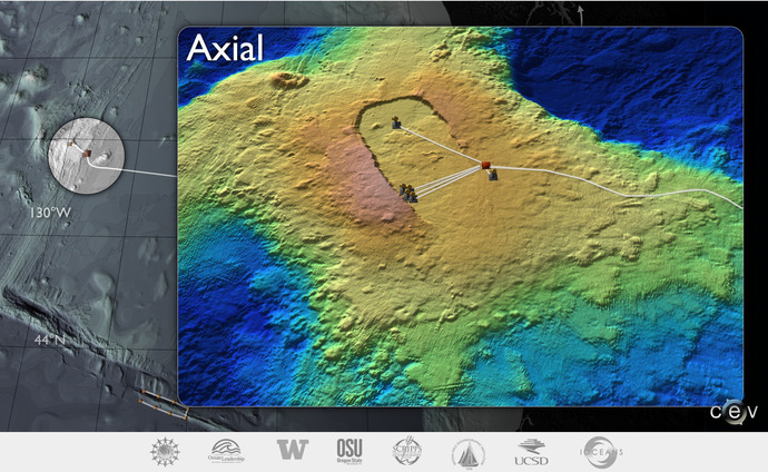
Observatories - Axial

Image Creation - Center for Environmental Visualization

Related Stories

OOI Regional Cabled Network: The Cabled Component of the NSF Ocean Observatories Initiative
 
Creative Commons License 

For commercial use or higher resolution please contact Nancy Penrose


Enlighten '10
Follow us on Facebook
Follow us on Twitter
YouTube
Flickr

University of Washington. All rights reserved. Website Development and Design: Center for Environmental Visualization