Overview
Related Content
RSN Hi-Level Block diagram


Axial Caldera Seafloo ...
Axial Seamount Core Measurements, Sensors, and Locations

Mooring Winch Package ...
The Winch Instrument Package includes 12 sensors mounted on the Float Package Win ...

Mooring Float Package ...
The Float Instrument Package includes nine sensors mounted on a Float Package bel ...

Mooring Profiler Pack ...
The Profiler Instrument Package includes five sensors mounted on a profiler that ...

Mooring Seafloor Pack ...
The Basic Core Seafloor Mooring Measurement Package includes seven instrument pac ...

Basic Core Seafloor P ...
The Basic Core Seafloor Measurement (BCSM) packages are located at Primary Nodes ...

Primary Infrastructur ...
The Primary Infrastructure is a major component of the RSN. It distributes power ...

Vertical Mooring Meas ...
The Vertical Mooring Measurement Package (VMM) is located at two sites, one ~1.0 ...


Low Power J Boxes
The second class of junction box is the Low Power J-Box (LP J-Box) that receives ...

Medium Power J Boxes
The Initial RSN system will use two types of junction boxes (J-Box). The first ty ...

Low Voltage Nodes
The LV Nodes interconnect junction boxes and their associated instrument platform ...
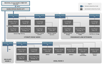
Secondary Infrastructure


Simple schematic showing the relationship between the Primary and Secondary Infrastructure for part of the Hydrate Ridge Site.
Primary Infrastructure Schematic

Primary & Secondary Infrastructure PDF
Primary & Secondary Infrastructure PDF
The RSN’s Secondary Infrastructure is shown schematically in the figure above. The Secondary Infrastructure includes all extension cables, medium power and low power junction boxes, low voltage nodes, two water column moorings, and seafloor and mooring sensor packages. This infrastructure is linked to the Primary Infrastructure by connection to the Primary Nodes, which distribute low voltage (375 V) and data at a lower rate (1 GigE) to a group of Low and Medium Power Junction Boxes (J-Box) and Low Voltage Nodes (LV) clustered geographically around the Primary Node. The Low Voltage Nodes are connected to Low Power Junction Boxes (LP-JBox) at 48V and100BASE-T that provide the correct data and power interface to small groups of scientific instruments. This system is described in more detail in the 2007 White Paper on RSN Secondary Infrastructure.
In concert, this infrastructure will support (at least) three general scenarios:
1. Local area networks around a Primary Node (e.g., Axial Seamount);
2. Water column moorings at two of the Primary Node sites (Hydrate Ridge and Axial Seamount), which extend the science capabilities from the seafloor to the sea surface; and
3. Extended spatial arrays (e.g., Hydrate Ridge/Coastal Endurance Array).