Regional Scale Nodes
  • Other Sites
    • Visions '11
    • OOI/Regional
    • Enlighten '10
    • Interactive Oceans
    • University of Washington
  • Home
  • Overview
    • Primary Infrastructure
    • Cyber Infrastructure
    • Secondary Infrastructure
    • People
  • Engineering
    • Moorings
    • Low Power J Boxes
    • Medium Power J Boxes
    • Low Voltage Nodes
    • Primary Nodes
    • Connectors
    • Cables
  • Locations
    • Mid-Plate PN-5A
    • Axial Caldera PN-3B
    • Axial 3000m PN-3A
    • Endurance Line PN-1C and 1D
    • Southern Hydrate Ridge PN-1B
    • Hydrate Ridge 3000m PN-1A
    • Pacific City Shore Station
  • Sensor Configurations
    • Axial Caldera Seafloor
    • Southern Hydrate Ridge Seafloor
    • Mooring Profiler Package
    • Mooring Float Package
    • Mooring Winch Package
    • Mooring Seafloor Package
    • Basic Core Seafloor Package
  • Schedule
  • Blog

Profiling Instruments Block Diagram

Profiling Instruments Block Diagram

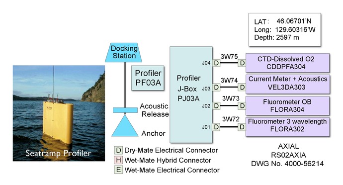
A Block Diagram for the Profiling Instruments Package for the water column mooring located 1.0 km NW of Primary Node 3A near the base of Axial Seamount. The image to the left shows Seatramp Profiler being deployed as an example profiler.

Creative Commons License 

For commercial use or higher resolution please contact Nancy Penrose


Enlighten '10
  • Terms
  • Privacy
  • NSF Disclaimer
  • Events
  • News
  • Contact Us
  • People
  • Search
  • Archives
  • Home
Follow us on Facebook
Follow us on Twitter
YouTube
Flickr

University of Washington. All rights reserved. Website Development and Design: Center for Environmental Visualization