Regional Scale Nodes
  • Other Sites
    • Visions '11
    • OOI/Regional
    • Enlighten '10
    • Interactive Oceans
    • University of Washington
  • Home
  • Overview
    • Primary Infrastructure
    • Cyber Infrastructure
    • Secondary Infrastructure
    • People
  • Engineering
    • Moorings
    • Low Power J Boxes
    • Medium Power J Boxes
    • Low Voltage Nodes
    • Primary Nodes
    • Connectors
    • Cables
  • Locations
    • Mid-Plate PN-5A
    • Axial Caldera PN-3B
    • Axial 3000m PN-3A
    • Endurance Line PN-1C and 1D
    • Southern Hydrate Ridge PN-1B
    • Hydrate Ridge 3000m PN-1A
    • Pacific City Shore Station
  • Sensor Configurations
    • Axial Caldera Seafloor
    • Southern Hydrate Ridge Seafloor
    • Mooring Profiler Package
    • Mooring Float Package
    • Mooring Winch Package
    • Mooring Seafloor Package
    • Basic Core Seafloor Package
  • Schedule
  • Blog

Axial Volcano

Axial Volcano

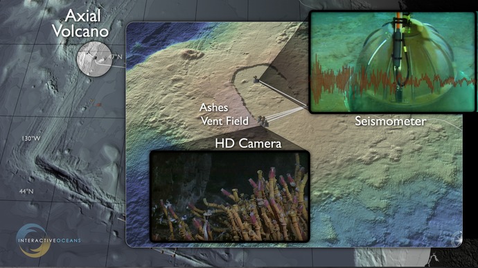
Direct connection of high definition video and digital still cameras, coupled with data from arrays of seismometers, chemical and biological sensors will provide new insights into process linkages among seafloor volanoes and life.
 

Related Stories

Mapping Axial Volcano
 
Creative Commons License 

For commercial use or higher resolution please contact Nancy Penrose


Enlighten '10
  • Terms
  • Privacy
  • NSF Disclaimer
  • Events
  • News
  • People
  • Contact Us
  • Search
  • Archives
  • Home
Follow us on Facebook
Follow us on Twitter
YouTube
Flickr

University of Washington. All rights reserved. Website Development and Design: Center for Environmental Visualization